What is Geofencing? How It Protects Your Vehicles and Fleet
By Velosyss Team · 3 May 2026
What is Geofencing? How It Protects Your Vehicles and Fleet
If you have ever searched for a GPS tracker and seen the word geofencing listed as a feature, you may have wondered what it actually means — and whether it matters for your use case.
The short answer: geofencing is one of the most practically useful features in any vehicle tracking platform. Once you understand it, you'll wonder how anyone managed without it.
What is Geofencing? (The Plain-English Explanation)
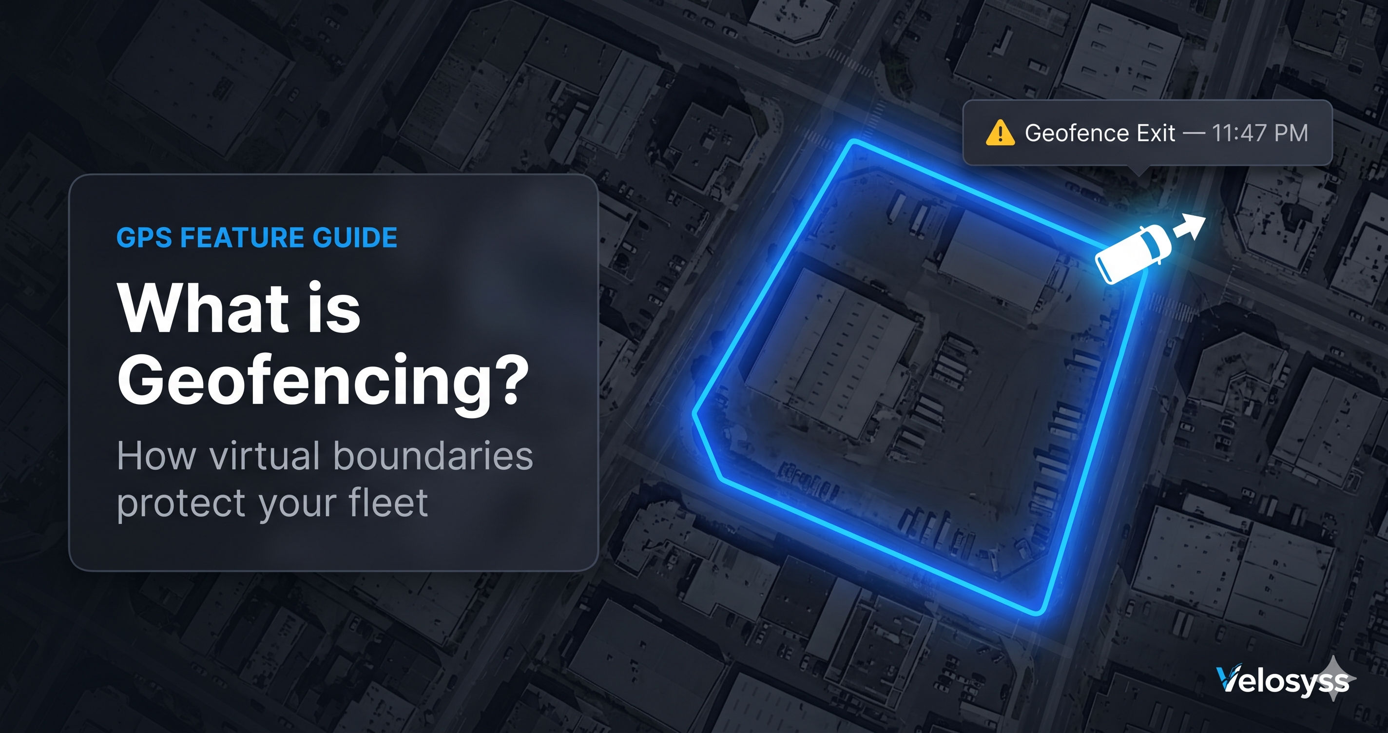
A geofence is a virtual boundary drawn on a digital map.
When you create a geofence, you are telling the system: "This area matters to me. If any of my vehicles enter or exit this area, alert me immediately."
That's it.
You draw the boundary on the map — either a circle (with a centre and a radius, like "a 500-metre circle around my depot") or a custom polygon (any shape, like the actual boundary of your industrial estate). The GPS tracking system then monitors every vehicle in your fleet and triggers an alert the instant any vehicle crosses that boundary.
Think of it like this: imagine a security guard standing at the gate of your depot, watching for vehicles coming and going, and sending you a WhatsApp message every time one moves. A geofence does this automatically, for every gate, for every vehicle, 24 hours a day — without error, without fatigue, without breaks.
How Geofencing Works Technically
The process involves three continuous steps:
- Tracking: Your GPS device reports its location every few seconds to the Velosyss server
- Evaluation: The server checks whether the latest position is inside or outside each geofence zone you have configured for that vehicle
- Alert: If the vehicle crosses from inside to outside (exit) or outside to inside (entry), the server immediately sends a push notification to your phone, an email, and an in-app notification
This happens in real time. From a vehicle crossing a geofence boundary to the notification arriving on your phone takes under 30 seconds with the Velosyss platform.
Circle Geofence vs. Polygon Geofence
Velosyss supports two geofence shapes:
Circle Geofence
A circle geofence is defined by a centre point (usually your address or a location on the map) and a radius in metres.
Examples:
- "Alert me if my delivery van goes more than 50 km from our Delhi office"
- "Alert me when the school bus enters within 500 metres of the school gates"
- "Alert me if my car leaves our neighbourhood area"
Circle geofences are quick to create and work well for simple radius-based rules.
Polygon Geofence
A polygon geofence lets you draw any custom shape on the map — following the actual boundary of an industrial estate, a city district, an airport campus, or a housing society. You simply click points on the map to define the boundary.
Examples:
- "Alert me if any vehicle leaves the boundaries of our factory compound"
- "Alert me when a delivery vehicle enters a customer's site (mapped to the exact boundary)"
Real-World Use Cases for Geofencing
1. Delivery and Logistics
A dispatch manager creates geofence zones around each customer delivery point. When a delivery driver's van enters the zone, the system logs a timestamp. When the driver exits, it logs another. The manager has automatic proof of arrival and departure without calling the driver or relying on manual check-in.
Additionally: if a driver goes off-route or enters an area they were not supposed to visit, the exit from the approved delivery zone triggers an alert.
2. Fleet Security After Hours
A vehicle rental company creates a geofence that covers the city area their vehicles are authorised to operate in. Between 10 PM and 6 AM, any vehicle that exits this zone triggers an immediate alert.
Without a phone call to a driver. Without a security guard watching a map all night.
3. School Bus Tracking
Parents and school administrators create two geofence zones: one around the school, one around the bus stand or major stops. When the school bus enters the school zone in the morning (dropping children off) and exits in the afternoon, parents receive automatic notifications — no need to call the school or check a separate app.
This is increasingly required by schools and parents in urban India. [INTERNAL LINK: School Bus GPS Tracking Guide]
4. Employee Vehicle Use
A business creates a geofence around their office and the local service area. Company vehicles used outside this zone during or after working hours trigger an alert. This creates accountability without micromanagement — drivers know the system is in place, which itself discourages misuse.
5. Private Vehicle — Family Safety
An individual creates a geofence around their neighbourhood. If a teenage family member taking the car goes beyond the defined area, the parent receives an alert. Not to punish — but to know.
How to Create a Geofence in Velosyss
Setting up a geofence in Velosyss takes under 2 minutes:
- Log in to velosyss.com or open the Velosyss app
- Navigate to Geofences in the dashboard
- Click Create New Geofence
- Choose shape: Circle or Polygon
- Click on the map to place the zone (drag to resize for circles; click points for polygon)
- Name the geofence (e.g., "Mumbai Office", "Customer Site A")
- Select which vehicles this geofence applies to
- Choose alert type: Entry, Exit, or Both
- Save
Done. The geofence is active immediately. [INTERNAL LINK: Subscription Plans — Geofence availability by plan]
Which Velosyss Plan Includes Geofencing?
| Plan | Geofence Zones |
|---|---|
| Silver | Not included |
| Gold | Limited geofence zones |
| Platinum | Unlimited geofence zones |
If geofencing is important to your use case (and for most fleet and business owners, it is), the Gold plan or above is recommended. [INTERNAL LINK: Compare All Plans]
What the Geofence Alert Looks Like
When a vehicle crosses a geofence boundary, here is what you receive:
Push notification (mobile):
"? Geofence Exit — Vehicle: DL 01 CA 1234 has left Mumbai Office Zone. 11:47 PM"
In-app notification:
A log entry with vehicle name, zone name, entry/exit direction, timestamp, and GPS coordinates.
Email (if enabled):
A summary email with all the same information plus a map link.
You can configure whether you want Entry alerts, Exit alerts, or both — per zone, per vehicle. [INTERNAL LINK: Configure Notification Preferences]
Frequently Asked Questions
Q: Can I create a geofence for a specific road or route?
A: Geofences are area-based, not route-based. For route monitoring, the trip history feature shows whether a driver stayed on or deviated from an expected route.
Q: How many geofences can I create?
A: On the Gold plan, a limited number of geofence zones are included. The Platinum plan includes unlimited geofences. [INTERNAL LINK: Plans Page]
Q: Will I get alerted if the vehicle just drives near the boundary?
A: No. Geofence alerts only trigger on a confirmed crossing of the boundary. A vehicle passing close but not crossing will not trigger an alert.
Q: Can I temporarily disable a geofence without deleting it?
A: Yes. Geofences can be enabled and disabled from the dashboard without deleting them.
Q: Can different vehicles have different geofences?
A: Yes. Each geofence can be assigned to specific vehicles. Vehicle A can have a "city zone" geofence; Vehicle B can have a "customer site" geofence — independently.
Start Using Geofences Today
Geofencing is included with Velosyss Gold and Platinum plans. If you are already on the Silver plan and want to upgrade, you can change your plan at any time from the account dashboard.
[Get the Velosyss GPS Tracker for Your Bike →] [Product Page]
[See All Subscription Plans →] [Pricing Page]
[Learn How Real-Time Tracking Works →] Click Here]